Mendocino Complex Fire Summary
The Ranch fire, which is being managed as a part of the Mendocino Complex, Started on July 27th on the north bound side of highway 20, east of Lake Mendocino. Fuels in this area consisted of grass, brush and Oak trees. The grasses along the highway led the fire rapidly becoming established and making a run upslope to the east. Due to winds in the area the first resources on scene were not able to catch this fire in its initial stages.
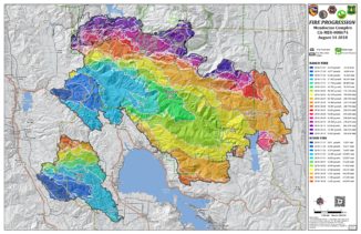
The Second fire being managed under the Mendocino Complex is the River Fire. The River Fire began on the east side of Old River Road, nearly 7 miles southeast of Ukiah, CA. Similar to the Ranch fire, the River Fire began in grasses and became rapidly established making a run up slope to the Southeast. The two incidents spread in a very similar manner for the first 3 days due to both fires burning in identical fuel types, and experiencing the same wind conditions during the initial attack phase. This is depicted very well in the fire progression map provided by the incident management team below.
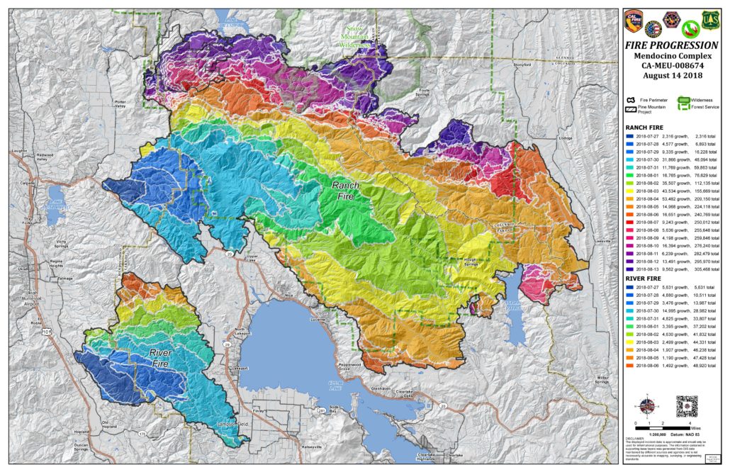
Fire progression map displaying the similarities in burn patterns for the initial 3-4 day period of these campaign fires.
Mendocino Complex as of August 16, 2018
The type-1 incident management team has been making significant progress with suppression efforts on these two fires. Currently the River fire remains with 48,920 acres burn and is 100 percent contained. The Ranch Fire has now surpassed the Thomas in acreage and claimed the title of California’s Largest Wildfire in recorded history. The Ranch Fire is currently 317,117 acres with 69 percent containment. The main influence of the Ranch Fire during the upcoming operational will be winds speeds. With the predominant winds coming from the west, the fire will continue push east. As these winds diminish this evening the primary driving factor of fire spread will switch to the local topography. This will likely change the direction of spread to the northeast. With the fire continuing to spread to the Northeast, there will be no shortage of fuel as it furthers its destruction of the Mendocino National Forest. Fire crews have constructed containment lines in this area and are preparing for a firing operation if the opportunity presents itself.
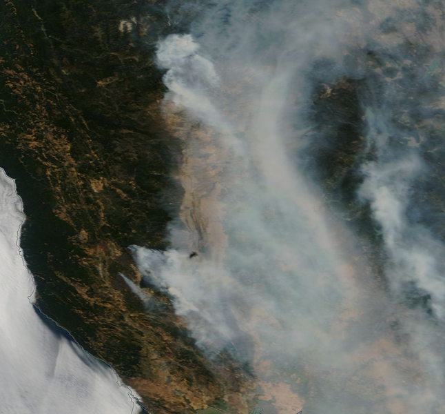
This image shows both the Mendocino Complex and the Carr fire’s smoke column from a satellites view.
Mendocino Complex Fire Facts
- As of: August 16th, 2018
- Location: Clear Lake, CA
- Size: 366,037 acres
- Containment: 76%
- Fire Behavior: Moderate Fire spread through heavy timber and brush in steep, rugged terrain.
- Structures Threatened: 1025
- Structures Destroyed: 147 Residences/118 Other
- Structure Damaged: 13 Residences/ 23 Other
- Evacuations: Are in place
- Incident Page: http://www.fire.ca.gov/current_incidents/incidentdetails/Index/2175
- News Article: ABC 7
2 Comments