2018’s fire season was another record breaking year; in particular, California was absolutely devastated in terms of lives and property lost. According to the National Interagency Fire Center in 2018, 8,582,609 acres were burned by 55,911 different wildfire starts throughout the United States. In comparison to the 2017 fire season, there were 991,924 fewer acres burned in 2018, from 8,699 less starts than 2017. These statistics paint a picture that this past season was not as severe in terms of wildfires, this could not be further from the truth.
California Specifics
Two records that were set during the 2017 fire season were, unfortunately, broken during the 2018 fire season. This year’s Mendocino Complex, in Mendocino County broke the record for most acres burned (459,123 acres) which was set in 2017 by the Thomas Fire (281,893 acres). The most recognizable fire that has impacted the state of California in nearly its entire history seemingly dwarfed the previous records of the most destructive fire, and most deadly fire in California’s history. The Camp fire in Butte County ripped through the foothill communities of Paradise, Concow, and Magalia, California in November 2018. Once the smoke settled, the Camp fire destroyed 18,804 structures and took the lives of 86 citizens on its path of chaos.
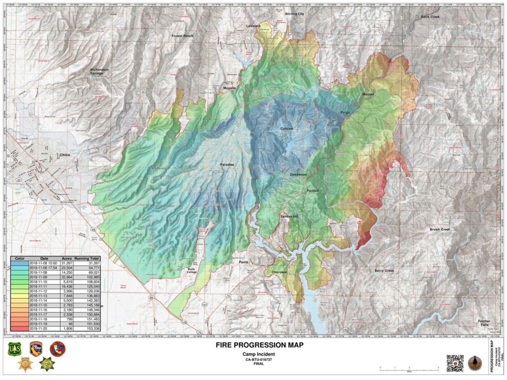
This map depicts how rapidly this fire destroyed the foothill communities of Paradise, Magalia, and Concow California.
Looking Back: Wildland Fire Potential Outlook for the 2018 Fire season
If we look back to last year’s Wildland Fire Potential Outlook at the beginning months of fire season, it was extremely apparent that the west coast was going to have a very busy fire season. With an upper level high pressure air mass parking itself over the west coast at the end of February, this essentially cut off the flow of moisture that would typically still be arriving to this area. These conditions resulted in the lighter fuels seeing their “green up” period sooner than is typically observed. In turn, these fine fuels were cured and ready to burn earlier in the season. To further this point, the heavy fuels in the forested areas were already at record level lows for fuel moisture content. These factors combined with strong wind events in local weather systems left the west coast ripe for an extremely active fire season to run its course.
Similar conditions were observed across the Midwest, as extreme drought continued to impact the majority of the central lower 48 states. Southern portions of the Midwest were experiencing the most potential for large wildfires during the months of May and June. These conditions quickly transferred to the Pacific Northwest, in July and August continuing all the way down the west coast.
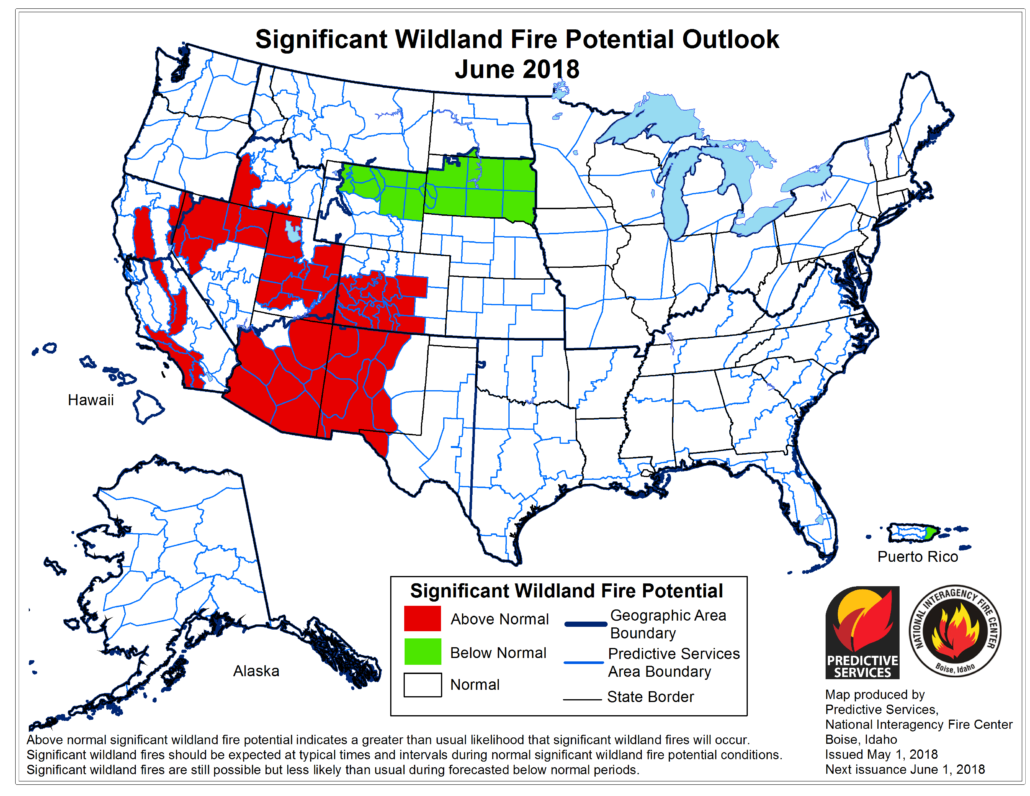
This map displays the extreme fire danger in the southern states during the month of June 2018.
With a mild El Nino pattern occurring in the ocean in the beginning of 2019, hopefully the moisture that has been present in the atmosphere throughout the lower 48 states will continue late into the spring months of this year. If these conditions persist and the moisture continues, this might allow for higher fuel moisture levels going into the warmer months of the year and may provide a small buffer of defense for the vegetation if, and when a fire starts.
2 Comments