MODIS has aided firefighters by providing daytime visible imagery and night-time information on active fires. It also has helped explain fire behavior. A recent study from the US Forest Service indicates, since the early 2000s, MODIS has detected a significant increase trend in nighttime wildfire activity. Additionally, the increase in MODIS coincides with larger, more intense wildfires.
MODIS Basics
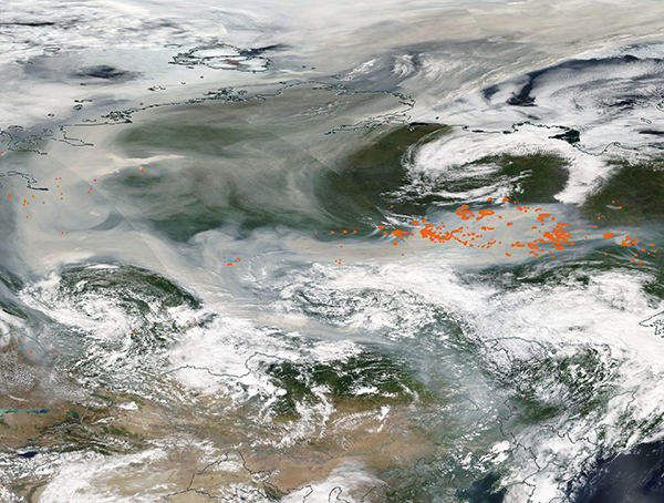
MODIS is the Moderate Resolution Imaging Spectroradiometer. This instrument, developed by NASA, is a polar-orbiting, high temporal, moderate spatial resolution sensor. It acquires remote sensing data for monitoring the Earth’s land, ocean, and atmosphere. Currently, two NASA EOS satellites carry the MODIS instrument. NASA launched Terra in December 1999 and Aqua in May 2002. Both send data to multiple fire-related agencies that use it for different purposes.

MODIS on the 2021 Dixie Fire from Terra.
For example, at the highest level, firefighting leaders use MODIS to identify multiple fires and determine where to allocate resources. It ensures incident management leaders are receiving near real-time actionable information. Furthermore, the data helps air resources work multiple fires with fewer takeoffs and landings. Additionally, at a local level, the sensors send data to the fireline to pinpoint fire location and intensity.
Most importantly, MODIS helps provide an image that combines a photographic snapshot with infrared imagery. In California in 2008, a test flight was sent over the Humboldt Fire using a data downlink system that was able to provide updated information to the incident managers. This was crucial in determining where to send firefighting resources and whether a full evacuation of the town of Paradise was needed.
Nighttime Wildfire Activity
Nighttime wildfire activity exposes firefighters to the risks of working in dark and dangerous conditions. It also limits their opportunities for rest and recovery. As we know, extreme nighttime fire behavior can quickly threaten communities. Therefore, understanding the potential for a wildfire to continue burning through the night has important implications for firefighters and community preparedness. Nevertheless, the spatiotemporal patterns of nighttime wildfire activity have received little attention across the conterminous United States.
The USFS published a new study where scientists used nearly two decades (2003–2020) of satellite observations from the MODIS to characterize the dynamics of wildfire across the US throughout day and night. These satellite observations considered vegetation fire type, wildfire size, and time of detection (day vs night).
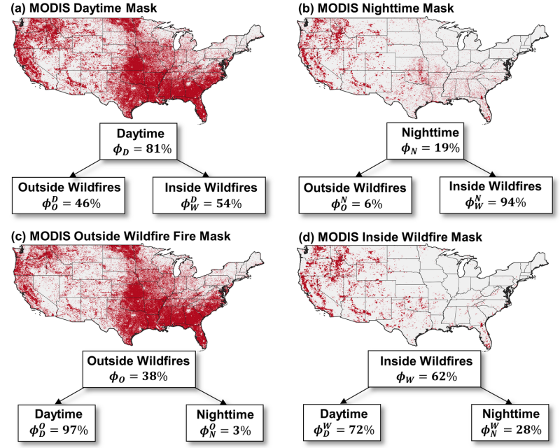
Picture depicting MODIS for active fire pixels detected during the daytime or nighttime as well as outside or inside wildfires.
Daytime fire activity was widespread both outside and inside wildfires, whereas nighttime fire activity was concentrated inside wildfires, and particularly within large wildfires in the western US. Additionally, analysis of coincident 1000-hr fuel moistures indicated that as fuels dried out, MODIS detected less agricultural and prescribed fire activity and increasingly larger and more intense wildfires with higher probabilities of nighttime persistence. Over the past 18 years, an increase in wildfire sizes coincided with a significant increase in nighttime wildfire activity.
MODIS and other similar instruments will continue to serve an important purpose in firefighting and understanding wildfire behavior.

2 Comments