Fall Means Santa Ana Winds
Annually, the onset of the fall and winter seasons brings the highest chance for Southern California’s famed Santa Ana winds. Historically, the worst fires in Southern California in terms of speed of growth and destruction are linked to these hot, dry wind events. The last two years, a strong and persistent Santa Ana event was a major player in the spread of both 2017’s Thomas fire in Ventura and Santa Barbara and 2018’s Woolsey Fire in Malibu. This week’s strong wind event marks the first real threat of the fall season in the region.
What Are Santa Ana Winds?
Typically Santa Ana air mass conditions are brought on by high pressure inland and lower pressure off the Pacific Coast which brings very hot and dry weather along with strong, down-slope winds. Santa Ana winds typically happen between September and May, in the winter months. We think this UCLA FAQ outlines Santa Anas the best. In the past, the critical fire weather conditions that accompany Santa Ana winds turn the typically dry chaparral of Southern California into explosive fuel. Some of the country’s costliest fires in history have taken place in these conditions.
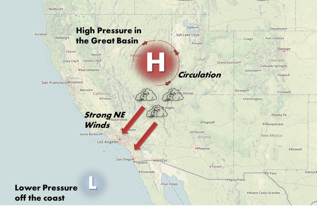
Santa Ana Winds derive from High Pressure in the Great Basin
The Outlook This Winter
Due to warmer and drier than normal conditions in October, drought conditions worsened across much of the west. It even expanded to the Plains, Midwest, Appalachians, and Southeast regions and now covers nearly two-thirds of the contiguous US. Cooler temperatures and shorter days have quelled fire activity in much of the west, but as this week’s fire weather shows the potential remains for California. Generally, offshore winds and dry fuels can keep fire activity going south of Pt. Conception into December.
As was true the last two winters, La Niña conditions are likely to continue through winter. Specifically, the Climate Prediction Center is forecasting a 75% chance of a a Niña continuing its winter influence for the next few months. As a result, high pressure off the California coast will dominate November through February. Expect normal temperatures and below normal precipitation to persist for the region a third year in row. Typically in La Nina conditions, the high pressure systems clear out, allowing Pacific troughs that drop southward into California. When that occurs, periods of showers and below normal temperatures are likely, but tend to be infrequent. The long term Predictive Services Outlook suggests that there will likely be enough precipitation for significant fire potential to be normal through winter.
This blog was originally posted on September 25th, 2019. It has been updated by RedZone November 16th, 2022.