The morning of November 30th, 2018, at 8:29 AM local time, a 7.0 magnitude earthquake shook the city of Anchorage, Alaska. The origin of the quake was 7 miles north of the city, resulting in the residents of Anchorage feeling the full intensity of this earthquake. Luckily, the epicenter was at a depth of 27 miles into the Earth’s crust. The depth of the origin allowed for the seismic energy of the earthquake to diminish slightly while making the 27-mile vertical journey before wreaking havoc on the surface.
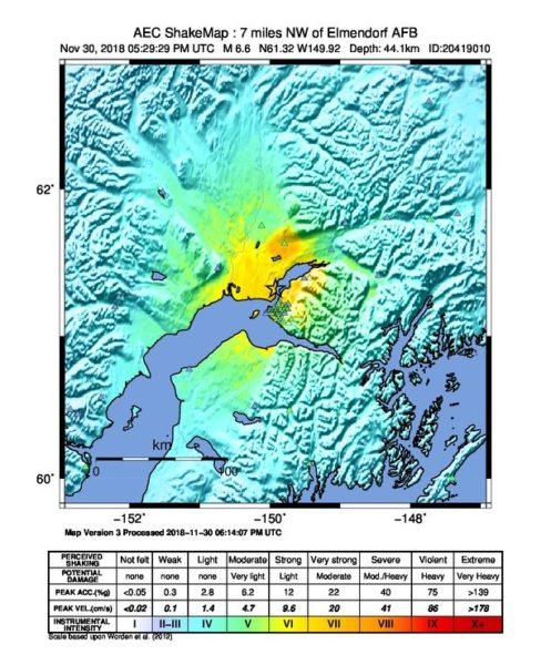
The Shake Map shows the extent and magnitude in the surrounding areas during the 7.0 earthquake near Anchorage, Alaska,.
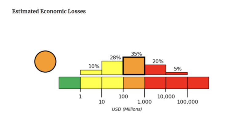
Upon reaching the surface, the resulting damages included widespread power outages, severe damage to roadways and other transportation infrastructure, and internal damage to residential and commercial structures. Immediately after the quake hit, the USGS released figures that contained frightening numbers depicting the probability of economic losses. The figure below shows that, according to the USGS predicted losses, there is a 35 percent chance of damages ranging from $100 million – $1 billion. The data goes on to show that there is a 20 percent chance that the economic losses could very well total over one billion dollars!
Immediately after the quake and ongoing through this week, the area continues to be inundated with relentless aftershocks that still hold immense power. As of this morning, the area has been the recipient of over 2,700 aftershocks and tremors, ranging in magnitude from 1 up to 5. There is still potential for an aftershock to be nearly as powerful as the original incident itself, which would cause even more damage during the recovery process.
Looking Back
In 1964, Anchorage fell victim to a 9.2 magnitude quake that caused damage to such an extent that certain parts of the city were unrecognizable. This earthquake killed 15 people during the event and another 124 from the resultant tsunami. Only one earthquake in recorded history has been more powerful (9.5 magnitude in Chile 1960). In the wake of this devastating event, the changes to the building codes may have resulted in massive economic saves in relation to building loss during this most recent quake. One of the key ideas that resulted from the research in the aftermath of the 9.2 magnitude event was the concept of integrating ductility into modern architecture and design. Ductility is the ability to bend without breaking, which helps absorb some of the seismic motion during an earthquake. One way this could be achieved in the case of concrete structures would be ensuring the right amount of steel reinforcement is located in the correct areas of the structure. This is just one example of the engineering constructs resulting from the Earthquake Hazard Reduction Act of 1977, which was sparked by the enormous 1964 earthquake.
Sources:
https://www.curbed.com/2018/12/3/18124154/alaska-earthquake-anchorage-building-codes
https://earthquake.alaska.edu/anchorage-m70-what-we-know-so-far
https://www.pe.com/2014/04/07/earthquakes-alaska-disaster-jolted-nation-into-making-changes/