
Colorado State released released its third forecast for the 2023 Atlantic hurricane season on July 6th. Since the first forecast, the outlook appears to be more active a season than originally thought. According to the release, forecasters are now calling for an above-average Atlantic basin hurricane season. The projected number of named storms increased by 5 and major storms doubled the now-modest April forecast.
As forecasted by summer in our April outlook, the tropical Pacific is currently characterized by El Niño conditions. El Niño conditions typically happen every three to five years, according to NOAA. Normally, they tend to quell hurricane activity a bit, due to increased vertical wind shear. Wind shear near the Caribbean Sea and other parts of the Atlantic Basin tends to “tear apart‘ Hurricanes. Specifically, this means the wind shear stalls the progression of formed storms around the time they reach the Windward Islands. Thus, storms that form in El Nino seasons don’t often gather steam in the Caribbean.
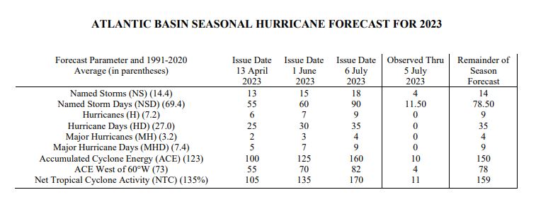
Comparisons of forecasts for 2023 Tropical Storm Activity from the Department of Atmospheric Science,
Colorado State University
July 6th Forecast
This was apparent in April’s below normal season forecast. As summer has arrived, so too has a clearer projection of normal to above normal tropical storm activity in the Atlantic. Despite these normalcies, this month’s updated forecast projects even more activity than June’s update. The graph above shows the increase. But, why the increase? Well, the report goes on to point to sea surface temperatures (SSTs) in the eastern and central tropical Atlantic are being at record levels. The thought here is that the abnormally high SSTs could trump the vertical wind sheer from El Niño Conditions in the Pacific. Only time will tell, but these SST measurements are the main driving forces behind the increase in forecasted activity.
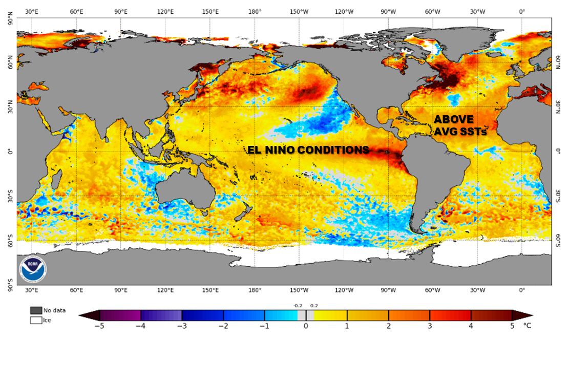
NOAA map showing Anomalies in Sea Surface Temperatures for Jul 19th, 2023. Source