The word Nor’easter has been quite prevalent in the media for the last two and a half weeks as a description for the type of storms that have been wreaking havoc across the east coast. Nor’easter storms get their name from the predominant wind direction that the system gets pushed in from. These storms are pushed from the Atlantic Ocean into the East Coast of the U.S., carrying massive amounts of water with them. A typical Nor’easter storm would consist of gale force winds (around 40 miles per hour and up), rough seas off the east coast, and massive amounts of precipitation in the form of rain or snow. The way these storms form and become so powerful is quite fascinating. The polar jet stream transports cold arctic air down over the United States and meets with the warm air of the jet stream located over the gulf coast. This collision of colder air over land and warmer moist air over the Atlantic Ocean is the driving force that creates these cyclonic storm systems. Nor’easters have been seen throughout all seasons of the year, but they are the most common and the most powerful between the months of September and April.
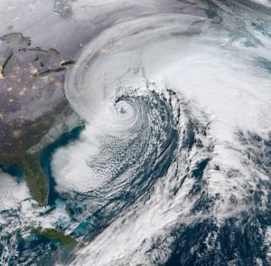
This Satellite imagery displays what the formation of a Nor’easter storm looks like from space.
Current Status of the East Coast
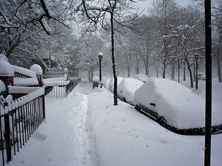
Yesterday, the third Nor’easter storm made landfall on the northern reaches of the east coast. The series of storms started on March second when winter storm Riley brought widespread precipitation in the forms of heavy rain and snow that earned the declaration for blizzard condition warnings in many counties. The storm hit the coast of New England with a force that would cause massive destruction. Storm surges brought about large scale coastal erosion, along with flooding of many coastal areas. At the peak of the first storm, over 1 million residents of New York, New England, and North Carolina were without power for an extended period of time. Riley was followed shortly after by winter storm Quinn. Quinn had a similar impact to the east coast, which was still trying to recover from the first storm. During this second large storm, thousands of flights had to be cancelled due to unsafe flying conditions for large passenger carrying aircraft. This storm system again passed through, leaving an absurd amount of snowfall, high wind speeds, and unsafe travel conditions. Finally, winter storm Skylar made its way to the east coast during the evening hours on Tuesday. Similar to the previous two storms that have occurred in the last two weeks, this powerful weather system left in its wake an abundance of rain and snow, accompanied by gale force winds and loss of power for hundreds of thousands of residents in the area. The storm surges seen during these storms are similar to what occurred during some of the hurricanes that hit the southern coast of the U.S. this year. You can read about the damages that occurred during these incidents in RedZone’s previous blog “Hurricanes Harvey and Irma batter Southern US”.
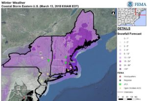
This map provided from FEMA shows the snow levels that are expected from winter storm Skylar.
Forecast for the East Coast
Unfortunately, forecasts for the east coast are looking like residents “aren’t out of the woods yet” when it comes to heavy winter storms. The discrepancies between the American and European forecast models are mainly surrounding the formation of this storm system once both air masses collide on the east coast. What is known is that another wave of cold air is making its way across the lower 48 states through this weekend. The cool air will arrive on the east coast late Monday night into Tuesday of next week. Due to the amount of time it will take for this system to make its way over to the east coast, meteorologists cannot say with certainty how powerful this storm will be. As the week progresses, the models will become more accurate, providing more details on the occurrence of this possible Nor’easter formation.
Sources: https://www.weather.gov/safety/winter-noreaster
https://weather.com/storms/winter/news/2018-03-14-snow-ice-west-midwest-east-mid-march