With climate change becoming more prevalent in recent years, science has been looking for ways to examine how changes to the earth’s present and past environment will affect the way wildfires will burn in the future. Fire regimes are a great start for looking into how climate change will affect the behavior, occurrence, and characteristics of how wildfires burn. According to Firescience.gov, the definition of a fire regime is “In general a fire regime characterizes the spatial and temporal patterns and ecosystem impacts of fire on the landscape”. Many characteristics of the environment go into shaping the fire regime in any given area.
Fire Regime Factors
Of the many factors within the environment that come into play when creating fire regimes, there are two critical aspects that shape how fires burn the most. The first of these two crucial factors is the dominant vegetation type within the ecosystem. Chemically, fires need three ingredients to burn, oxygen, heat, and fuel (vegetation). Therefore, if any one of these is removed an ignition cannot occur. History tells us that the type of vegetation is a key factor because of how large the difference in fire behavior is between fuel types. A second major factor involved in formulating a fire regime for a certain area is climate. The local weather patterns in an area have a huge impact on how a fire will burn through the geographic region in question.
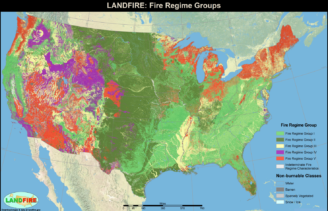
Lower 48 United states classified into fire regime zones.
In the formation of these regimes, fire ecologists have used data regarding vegetation classifications pertaining to the dominant vegetation type in the area. This is combined with historical fire information such as, fire perimeters, and fire conditions to get an understanding of how fire acts within the landscape. Lastly, fire return interval rates are used to determine, on average, how long it will take to have a fire reoccur in a landscape that has burned.
Fire Regime Classification
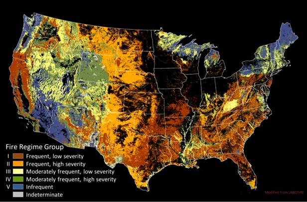
Over the years fire ecologists have made many attempts at creating fire regimes for the United States using a variety of weighted combinations and factors similar to what was mentioned above. Recently, one group has emerged with the most thorough and up to date classifications of fire regimes. LANDFIRE has created a robust model that incorporates the historical aspect of past fires, and what is projected for the future of the landscape. This will provide a base platform for future research to see how wildfires occurrence, and characteristics are changing as the climate continues to change. Below is a map of the United States classified by each regions respective fire regime as well as, the legend that explains what each level of classification means for that specific area.
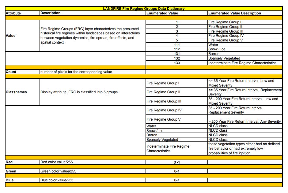
This table shows the characteristics behind the fire regime classifications listed on the map above.
Sources:
https://www.firescience.gov/projects/09-2-01-9/supdocs/09-2-01-9_Chapter_3_Fire_Regimes.pdf
https://www.landfire.gov/fireregime.php
https://www.fs.fed.us/database/feis/fire_regime_table/PNVG_fire_regime_table.html