Whittier Fire Summary
The Whittier Fire is suspected to have been sparked by an emergency vehicle accident around 1:30 pm Saturday afternoon and quickly spread to vegetation in the middle of the weekend’s red flag warning conditions. Officials stated that temperatures were over 110 degrees at the origin of the fire and within 2 hours the fire had spread to both sides of Highway 154 forcing the closure of the highway and evacuation of area camp grounds. Early on, Whittier Camp was evacuated and it was learned that the nearby Circle V Camp had dozens of children present. That camp was immediately threatened with no transportation for a safe evacuation as their escape route was cut off by the growing fire. In a press briefing today (7/14), several emergency responders shared the harrowing details of the evacuation of the Circle V Camp. The story describes how one Forest Service patrol and one dozer amazingly made it to the 80 camp counselors and children. The heroes assured them that they were safe while helping coordinate their evacuation to safety. A video was also released showing a sheriff’s deputy forced into turning around due to fire activity up the road. A timeline of the events can also be seen here.
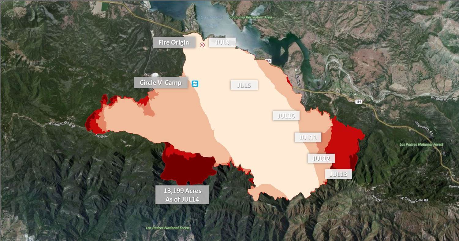
Whittier Fire Progression between July 8th and 14th. Now over 13,000 acres.
Whittier Fire Outlook
As you can see from the Santa Ynez Peak webcam below, fire activity has increased significantly today with the return of high pressure. The system is set to bring increased fire activity through Sunday. As the fire has grown this afternoon, the IMT is particularly worried about forecasted gusts of 25-30 mph through passes and gaps in the vicinity of the fire. As a contingency plan, ranch roads, dozer lines, and hand lines have been built and improved upon over the last couple operational periods. The idea here is to create large buffers between Goleta-area homes and the fire area due to the potential for the currently ongoing sundowner winds. Nonetheless, additional Evacuations have been ordered in the last three hours. Reports have significant activity occurring on both east and west sides of the fire, and especially to the south as the fire is headed in three different directions. The fire is actually approaching last year’s Sherpa Fire burn scar near Goleta.
Whittier Fire Evacuations
- All of Winchester Canyon Road excluding the community of Wagon Wheel, Langlo Ranch Road and Winchester Commons west to El Capitan Ranch Road.
- Calle Real north to West Camino Cielo from Winchester Canyon Rd on the east to El Capitan Ranch Road on the west.
- Paradise Road
- Rosario Park and all of Stagecoach Road
- Farren Road and Las Varas Canyon Road
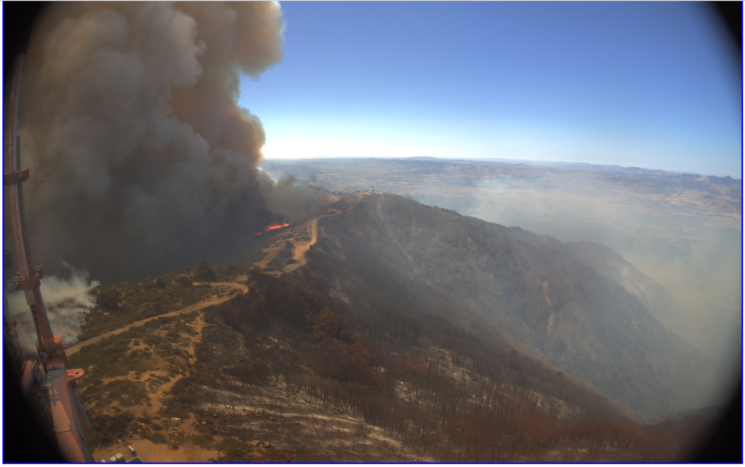
View looking West from Santa Ynez Peak Cam Friday Afternoon (July 14th)
Whittier Fire Facts
- As of: July 14th, 2017
- Location: Lake Cuchuma, Santa Barbara County, CA
- Size: 13,199 acres
- Containment: 52%
- Fire Behavior: Rapid fire spread through thick brush and timber in steep, rugged terrain.
- Structures Threatened: 1500 (reported)
- Structures Destroyed: Eight homes and 12 outbuildings have been destroyed
- Evacuations: Are in still in place
- Incident Page: http://inciweb.nwcg.gov/incident/5339/
- News Article: KEYT Santa Barbara
Sources: Inciweb, KEYT, Los Padres National Forest, http://www.rntl.net/santabarbaracountyfirecams.htm
One Comment