Three of the past four years have set wildfire records for acres burned, damaged and destroyed structures, and even deaths. To address the increasing risks to life, property, and the environment, the United States Geological Survey released a new strategy to use science, research, and technology to better address fire risks before, during, and after they happen. The Wildland Fire Science Strategy is a fire year plan that will guide USGS research to address the changing needs for the future of wildland firefighting.

Annual acres burned by wildfires in the United States, 1983–2019 (left), and Federal firefighting costs for suppression activities, 1985–2018 (right). Notable are an overall increase in acres burned and a steep increase in the Federal costs to fight wildfires since the mid-1990s Credit: National Interagency Fire Center, 2020
Pre-Fire
The information gathered from this strategy will allow land managers to address fire risks before the fires occur. It will also address things like climate change and supporting traditionally underserved rural and tribal communities when developing fire response plans. New fire behavior models, fire weather models, 3D fuel load data, and smoke models will help improve pre-fire mitigation.
During a Fire
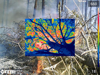
Researchers are planning to use technology to better track, model, and predict active fire behavior. New satellite and drone technology will help with early identification of fires, monitoring fire spread, and mapping perimeters. Better detection and active monitoring technology will also improve the safety of first responders and the general public. Updated databases and standardized geospatial data will help federal, state, and local firefighters share information more quickly and easily.
Post-Fire
An increasing threat to communities post-fire is debris flows. As the fire season extends later in the year due to climate change, particularly in the West, it narrows the gap with the rainy season. Brush and grasses whose root systems hold soil, rocks, and other debris in place during the rains do not have time to regrow after these increasing late fall fires. This new strategy will bridge fire and post-fire science to make recovery and post-fire mitigation more effective. It will observe burn severity simulations and identify any post-fire hazards. Addressing post-fire hazards will also allow for faster ecosystem recovery.

This home was severely damaged by a debris flow after the 2017 Thomas Fire.
Credit: Jason Kean, USGS
Sources:
Read the news release here.
Download the full report here.