Earthquakes have caused massive devastation, and amounted to huge numbers of human casualties since the beginning of recorded history. The problem with these natural disasters has become compounded by our cities becoming developed more vertically in the form of taller buildings without the proper respect given to earthquakes during the engineering process. Along with the previously mentioned factor, the general population that doesn’t live in earthquake prone areas won’t know what to do in a situation like this. You can learn more about how to prepare yourself, and what to do during an earthquake event in RedZone’s blog. This blog will hopefully assist in understanding the geoscience that is occurring before, during, and after one of these events takes place.
The Earth’s Crust and Earthquakes
Of the inner Earths four internal layers, the crust and the upper most portion of the mantle play the most vital roles in the unseen processes that power earthquakes. The Earth’s crust is made up of 12 major plates that are very dynamic in nature.
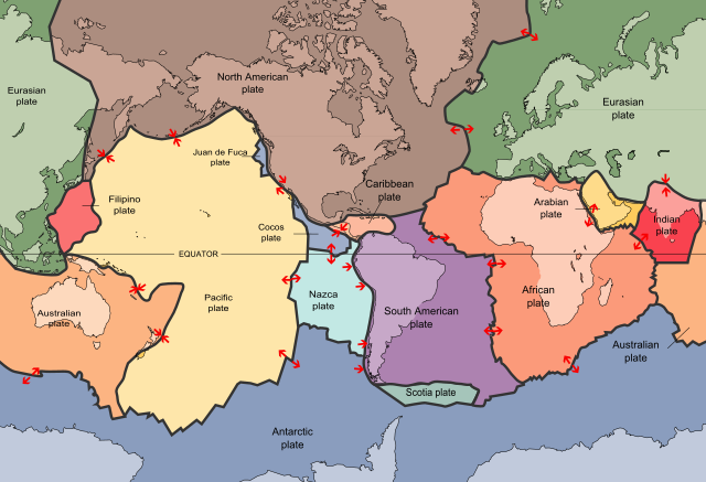
This map displays the 12 major tectonic plates throughout the world.
It is here at the tectonic plate boundaries that the earthquakes originate. As the plate boundaries come to a resting place due to its jagged edges, the remaining portion of the plate remains in constant movement. When the energy from the movement of the rest of the plate becomes too much force for an area of the plate boundary to hold, the edges of these plates shift and this is what causes an earthquake. The earthquake we feel on the ground stems from the seismic waves that are produces when the tectonic plates shift.
There are two primary wave types that are produced by this tectonic shift, the P wave (primary) and S wave (secondary). P waves have also been called the compressional waves due to the way these waves push and pull the matter they are travelling through. S waves are the waves we feel on the surface that create the movement on the earth’s surface. S waves are much slower to appear than the P waves for a seismologist to read.
Seismographic Readings and Determining the Epicenter
Scientists with their particular field of study in earthquakes, track these waves to give the public a rating on the Richter scale of how strong in magnitude an earthquake is. These experts also utilize the seismographs to locate where exactly the epicenter was. Triangulation is used to determine the precise location where the epicenter is. Three seismographs measure the difference in times that the P waves arrive at the seismographs and compare them with the time it take for the S waves to arrive at the same location. A circle is then created around the three selected seismograph locations with the radius being determined off the aforementioned time difference in seismic wave arrival. The point at which each of the three seismographs calculated circles meet is the epicenter.
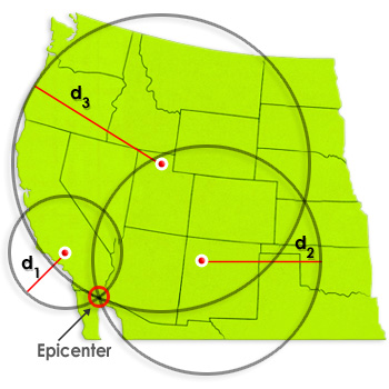
This diagram depicts a visual representation of how the epicenter of an earthquake is found from three seismographs.
Predicting Earthquakes
Unfortunately scientists have been unsuccessful so far in the prediction of when the next earthquake will occur. Earthquake prediction is more often defined as the probabilistic assessment of general earthquake hazard, including the frequency and magnitude of damaging earthquakes in a given area over years or decades. Like many naturally-occurring phenomena, they are nearly impossible to accurately predict. Prediction methods go back hundreds of years.j Methods generally involve precursors which among them include animal behavior, gas emissions, and even electromagnetic anomalies. Generally, Earthquake prediction is thought of as an immature science with any claims of prediction found circumstantial and arguable.
Earthquake warning systems on the other hand have proven successful on a number of occasions especially in areas farther from an epicenter. The effectiveness of the warning depends on the position of the receiver. After receiving a warning, a person may have a few seconds to a minute or more to take action. Areas near the epicenter may experience strong tremors before a warning is issued. Early warning systems have been prevalent in Japan, Mexico, Canada, and the United States for years.
Sources:
https://pubs.er.usgs.gov/publication/fs20163020
https://earthquake.usgs.gov/learn/kids/eqscience.php
https://earthquake.usgs.gov/learn/facts.php
https://www.nationalgeographic.com/environment/natural-disasters/earthquakes/
http://www.geo.mtu.edu/UPSeis/waves.html