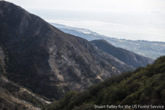
While the threat of the Thomas fire just recently diminished in Ventura and Santa Barbra Counties, residents were weary to hear that they are now being threatened by mudslides originating from within the burn area. Rain started Monday afternoon in the areas of Santa Barbara and Ventura Counties, with the peak rainfall being around 2:30 AM Tuesday morning. The rain came down in amounts up to an inch per hour over the burned area, which the incident commander reported as being a critical factor in the amount of sediment and debris being carried by this amount of water. The devastating debris flow ranged from Cold Springs Canyon to Toro Canyon, and wreaked havoc all the way down to Highway 101. The debris flow was so strong in some locations that it pushed homes off of their foundations and carried them several hundred feet.
First responders have been preparing for this incident since Monday morning by preemptively staging resources in the areas that were forecasted to be impacted the most severely. This strategic placement of resources was followed by officials releasing evacuation zones. The warning stated that all residents within mandatory evacuation zones should leave by 12 noon on Monday in preparation for the heavy rains that were forecasted for the area. Since the early morning hours of Tuesday, first responders have been in a search and rescue mode: still actively engaged in performing helicopter and contact rescues. The threat from this debris flow still remains and first responders are warning residents to stay away from the area if at all possible.
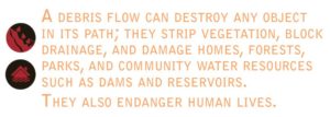
An explanation of a debris flow, and its power.
Over the last couple weeks of the Thomas Fire the Federal Burned Area Emergency Response (BAER) Team has been evaluating the blaze’s impact to the fire area and watersheds by predicting debris flow hazards should rains like this impact the area. The orange, red, and dark red areas were determined to have the highest probability of debris flow during a heavy rain event. The BAER team is currently embedded with the Santa Barbara and Ventura Office of Emergency Services to assist them in implementing response plans for communities downstream of the fire.
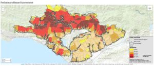
The map above displays estimates of the likelihood of debris flow (in %), potential volume of debris flow, and combined relative debris flow hazard.
Santa Barbara/Ventura Flooding at a Glance
- 17 confirmed deaths related to the storms (These numbers are subject to change as the incident continues)
- 13 missing people
- At least 25 injured
- 50 rescues via helicopter hoists have been performed during today’s search and rescue operations.
- 1-6.5 inches of rainfall over the Thomas Fire area.
- Search and rescue efforts still remain priority with approximately 75 percent of the primary search completed in the debris flow area.
If you liked the material in this blog, you can read similar material RedZone has covered here.
Sources
http://www.cnn.com/2018/01/09/us/southern-california-evacuations-rain-flooding/index.html
http://www.latimes.com/local/lanow/la-me-ln-rainfall-mudflow-20180109-story.html
https://landslides.usgs.gov/hazards/postfire_debrisflow/detail.php?objectid=178
3 Comments