Milne Fire Summary
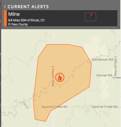
The Milne Fire began Monday (2/27) afternoon in the Hanover area southeast of Colorado Springs, and burned over 7,000 acres in roughly 2 hours. The initial report listed the originating location near Milne & Squirrel Creek Roads (southern tip of estimated fire perimeter below). Sustained winds over 20 mph were observed along with relative humidity levels under 20%. The gusty winds have blown out of the southwest, fanning the fire to the north and east. Given the rapid spread of the fire, it is not surprising that the fire area had been under Red Flag Warning conditions most of the day.
The El Paso County Sheriff’s office promptly evacuated over 600 residences in the fire area, and sent local school kids home early. The latest update from Hanover Fire Chief, Carl Tatum, stated that the fire had peaked at 7,000 acres by 5pm MST with an unknown number of structures involved. RedZone’s estimated perimeter in the map below reflects the nearly 7,000 reported acres.
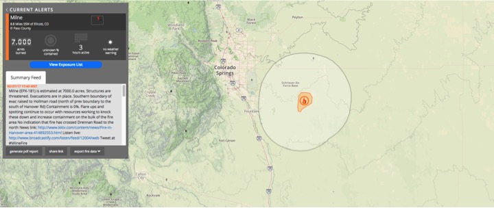
Milne Fire shown Southeast of Colorado Springs on RedZone’s Incident Dashboard
Milne Fire Outlook
Several local fire departments had taken over unified command of the fire as of Monday evening. Since the Milne Fire area is flat and mostly grassy, mop up and containment efforts shouldn’t be too difficult, and it’s likely firefighters caught the active fire front within hours. Flare-ups and spotting are possible with resources working to knock these down and gain containment on the bulk of the fire area. Crews continued to fight the blaze until around 9pm MST Monday while monitoring overnight.
Monday’s gusty winds and low RH are set to both improve by Tuesday, with the majority of the extreme fire threat moving further south and east into New Mexico, Oklahoma, and Texas. The National Weather Service is forecasting extreme fire conditions for a 32,000 square mile area in the Southwest, well south and east of the Milne Fire Location. The area includes Lubbock and Levelland, TX, as well as Hobbs, Artesia, Carlsbad and Hobbs, NM.
Milne Fire Facts
- As of: February 27th, 2017
- Location: Hanover, CO
- Size: 7,000 acres
- Containment: unknown
- Obs. Fire Behavior: Rapid fire spread through tall grass.
- Structures Threatened: 602 (reported)
- Structures Destroyed: unknown/none reported
- Evacuations: Have been lifted as of 6:45pm MST
- News Article: The Gazette
Sources: The Gazette, KKTV11News, El Paso County Sheriff’s, Hanover Fire
UPDATE (2/28 8:30PST)
Late last night (2/27), it was reported that the Milne Fire actually burned 5,000 acres, or 3,275 acres if unburned fuel within the fire perimeter isn’t included. This number was reduced from its original estimate of 7,000 acres after aerial mapping was conducted of the fire yesterday evening.