Junkins Fire Summary
The Junkins fire started early Monday morning (10/17) in the Junkins Park area of Custer County Colorado during Red Flag Warning conditions. The fire exhibited extreme fire behavior due to dry conditions and 70 mph wind gusts. Officials moved to evacuate homes in the immediate fire path as the fire quickly burned to over 15,000 acres as of 1:30 pm today (10/18). A type-1 incident management team has been ordered and is expected to take over command of the fire tomorrow morning (10/19/2016).
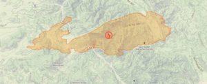
The Junkins Fire perimeter as of October 18, 2016
Fire Outlook
Officials expect fierce winds to continue through tonight, but the fire’s growth has slowed as firefighters focus on structure protection and building containment lines. There has been some significant progress made on the north side of the fire, and fire officials are hopeful to stop forward progress of the north front overnight. There are four air tankers, seven helicopters, and 115 firefighters on scene, with more resources on the way.
Example Fire Facts
- As of: October 18th, 2016
- Location: 11 miles east of Westcliffe, CO
- Size: 15,751 acres
- Containment: 0%
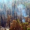
- Fire Behavior: Rapid fire spread through conifers, aspen and grass.
- Structures Threatened: 281 (reported)
- Structures Destroyed: 7 (2 homes and 5 outbuildings)
- Evacuations: 250 homes are under mandatory evacuation and 3,500 homes are in a pre-evacuation status.
- Incident Page: http://inciweb.nwcg.gov/incident/5071/
- News Article: The Gazette