Erskine Fire Summary
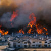
The Erskine fire started the afternoon of June 23rd along Erskine Creek Road in Lake Isabella and quickly spread up-slope and to the east toward several residential areas near South Lake, CA. Public safety officials quickly scrambled to evacuate the closest neighborhoods of Yankee Canyon, Mountain Mesa, and Squirrel Valley. As the fire rapidly spread east, skirting the mountains and neighborhoods above the lake, it destroyed homes and forced further evacuations of South Lake, Bella Vista, Onyx, Weldon, and Lakeland Estates.
Fueled by relative humidity (RH) in the single digits and gusty evening winds, the fire quickly spread ten and half miles over a matter of hours in the time from Thursday evening to early Friday morning. As of midday Friday (6/24) the Erskine Fire was 19,034 acres and 0% contained. Fire officials are reporting 100 structures are estimated as lost and 1,500 others are threatened. A damage assessment team will survey the extent of the fire’s destruction in the coming days.
Erskine Fire Outlook
A type-1 incident management team is already en route to the area to take over command of the fire. The Erskine Fire exhibited extreme fire behavior across steep, rugged terrain fanned by gusty afternoon winds. Fire officials are worried about this afternoon’s (6/24) weather forecast, which may mimic yesterday’s destructive conditions. There are six air tankers, seven helicopters, and 800 firefighters on scene, with hundreds more on the way.
Erskine Fire Facts:
- Location: Lake Isabella, CA
- Size: 19,034 acres
- Containment: 0%
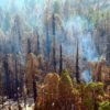
- Fire Behavior: Rapid fire spread through tall grass and brush in steep, rugged terrain.
- Structures Threatened: 1500 (reported)
- Structures Destroyed: 100 (estimated)
- Incident Page: http://inciweb.nwcg.gov/incident/4806/
- News Article: LA Times
Map: Erskine Fire perimeter (as of 6/24, 1300 hrs).
NOTE:
Fire perimeter was provided by NIFC and was created by hand and helo flight GPS.

One Comment